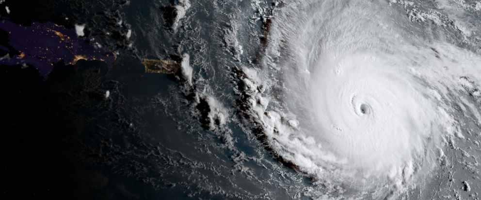

Hurricane Irma: One of the most powerful Atlantic Ocean storms on record
On Tuesday, 5th September 2017, Hurricane Irma became one of the Atlantic’s most powerful storms. The category 5 hurricane - the highest category storm on the Saffir-Simpson scale (a commonly used scale that attempts to measure potential property damage from storm winds) - had wind speeds around 185 mph, matching those of Wilma in 2005 which killed 87 people, costing billions in damage. As it moved through the Caribbean and towards southern Florida, Irma sustained winds of 185 mph for 37 hrs, making it the longest on record any tropical cyclone around the world has maintained this intensity.
It almost wholly destroyed Barbuda as 185 mph winds pummeled 10 Caribbean islands and US territories - including St Martin, the British Virgin Islands, Haiti and the British territory of Turks and Caicos, and Cuba - before hitting Miami and blasting up the west coast of Florida at the weekend, with dangerous flooding along stretch of the beach and 3.4 million homes without power. Irma killed at least 28 people, left dozens injured and caused widespread damage.
Hurricane Meteorology
Atlantic hurricanes begin life as stormy disturbances off the west coast of Africa – there are around 60 of these each year, but most peter out, with only a few growing into hurricanes. Now for this to happen, we need three ingredients: warm ocean waters (at least 26.5°C) to fuel the growth of the storm, moisture in the mid-atmosphere (~5 km) and a lack (<23 mph) wind shear through the height of the atmosphere, as hurricanes need to maintain vertical structure. Whilst warm ocean waters are abundant across the tropical Atlantic during the hurricane season (June-Nov), the last two ingredients are less consistent, but when they are present, hurricanes may develop.
We use a Saffir-Simpson scale which ranges from 1 to 5, to categorise hurricanes – it’s a commonly used scale that attempts to measure potential property damage from storm winds. For example, Irma is a category 5 storm which is extremely rare and unusually strong, with wind speeds exceeding 157 mph. These storms can cause complete destruction of building roofs, trees, and power lines.
On average, there are usually no more than 2-3 hurricanes with a rating above 3 each season, which shows how unusual the present situation is.
How is Irma different from Harvey?
Irma and Harvey were pretty different storms. Hurricane Harvey was a category 4 at its peak and brought catastrophic flooding to Texas and Louisiana – it became fairly stationary and dumped 33 trillion gallons of water onto the region.
Irma is a category 5 and one of the strongest ever recorded. But rather than torrential rainfall being the main issue, it is the wind speed and storm surges that are the main problems – unlike Harvey, it moved faster through the Caribbean.
A succession of strong storms
First came Hurricane Harvey, which barreled into Texas and Louisiana in August, and now Irma, one of the most powerful hurricanes on record, is battering the Caribbean and has Florida in its sights. Jose and Katia – currently tropical storms out in the Atlantic - may well reach hurricane strength in the next few days. Katia is the fourth named storm in two weeks.
So is this unusual? We’re in peak hurricane season for the Atlantic - the formation of several storms in rapid succession is not uncommon at this time of the year. Indeed, it’s when 95 per cent of hurricanes form. However, what is rare is having a succession of two such strong hurricanes (category 4 and 5) in this space of time. Since records began in 1985, the US had never been hit by two Category 4 or stronger hurricanes in the same season. Also, some of these storms are falling outside their normal range - for example, Irma is the easternmost on record.
There are possibly more to come, with tropical storms Jose and Katia potentially becoming major hurricanes in the next few days.
Did Irma take people by surprise?
Not entirely. A third of the way into the 2017 Atlantic hurricane season, it looked like the region would likely experience “an above-normal hurricane season” that “could be extremely active,” with more named storms than previously expected -14 to 19 this season, with two to five major hurricanes.
Now, halfway through the season, this is being realised – so far, there have been 12 named storms, four of which strengthened into hurricanes (with maximum sustained winds above 73 miles per hour).
The difficulty, however, is predicting precisely which of the stormy atmospheric disturbance flowing off the West African coast will peter out and which will turn into something stronger. And if they do strengthen, what path will they take?
What impact is climate change having?
Climate change does not ‘cause’ hurricanes, but it does have an impact. In a warming world, we expect the likelihood of extreme weather events, such as Irma, to increase. Indeed, the intensity and duration of North Atlantic hurricanes, and the frequency of category 4 and 5 hurricanes, have increased since the early 1980s. However, attributing extreme weather events to climate change is a complex science; natural and human factors combine to determine how a hurricane develops and what impact it has.
As global temperatures continue to rise, the water cycle gets more active. There is more evaporation from the Earth’s surface and more condensation of water vapour into raindrops in the atmosphere. Together with warmer sea surface temperatures locally (surface temperatures in the eastern half of the tropical Atlantic Ocean were between 0.5°C and 1°C above average in the summer of 2017), this can contribute to more major hurricanes (Category 3+) with higher rainfall rates, stronger winds and drastic impacts. On top of that, sea levels have been rising (half a foot higher in recent decades) as the water gets warmer and expands, and ice melts, which will have an impact on storm surges.


