
Cut-off lows, cold drops and DANA
by Kirsty McCabe, FRMetS
It’s hard to comprehend the volume of rainfall that led to deadly flash floods in southern and eastern Spain in autumn 2024, and our thoughts remain with the people who have been affected by this devastating event. Over a year’s worth of rain fell in a matter of hours, leading to devasting floods, extensive damage to infrastructure and the deaths of over 200 people, with many still missing.
Torrential rains caused deadly flooding and extensive damage in the province of Valencia, located in eastern Spain. These #Landsat images show the extent of flooding as of October 30, 2024.
More: https://t.co/nuE0Vr7cNT pic.twitter.com/EGOaJ8mcTy— NASA Earth (@NASAEarth) November 1, 2024
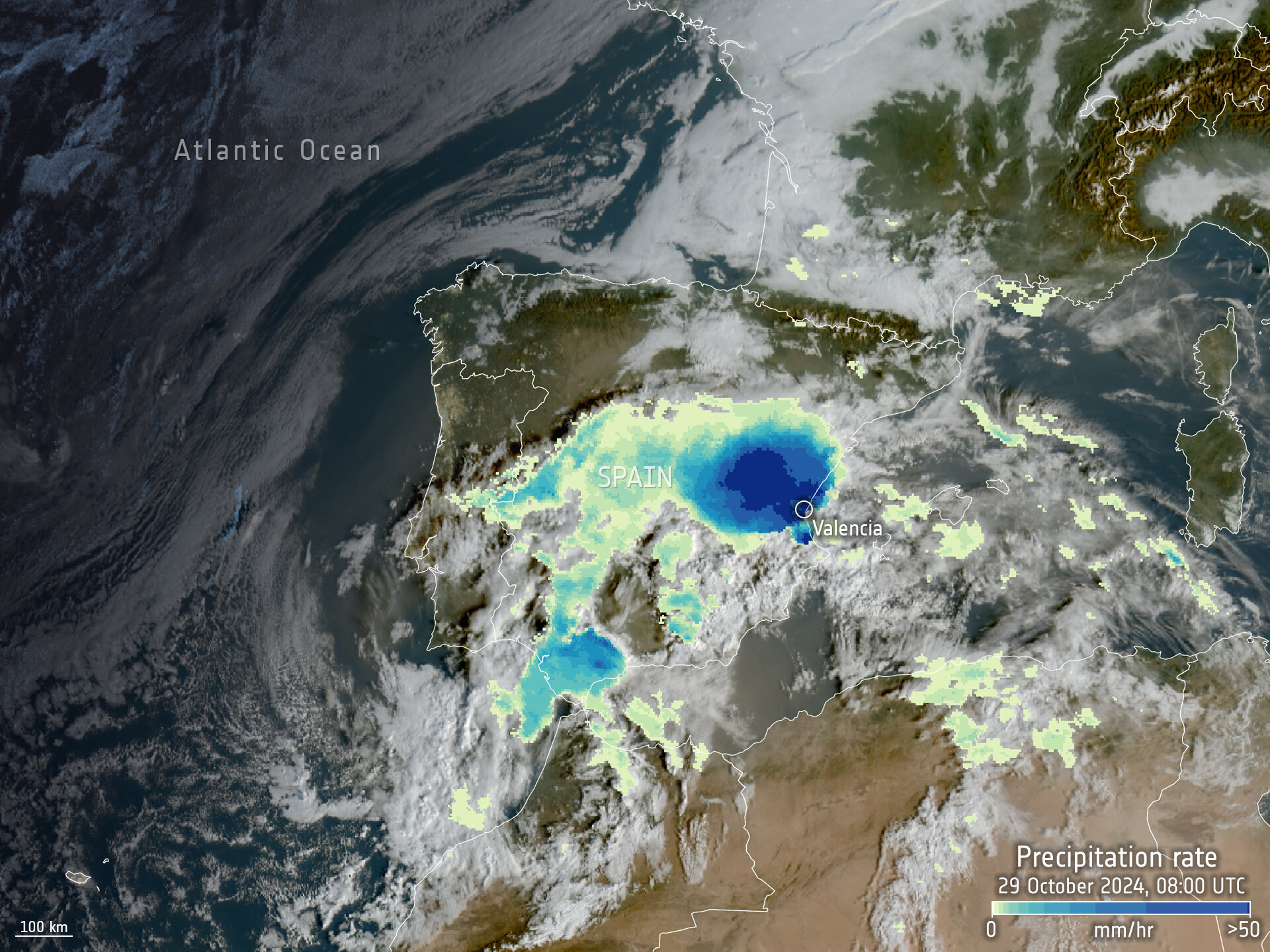
The torrential downpours of 29 October 2024 were due to an event known locally as a DANA — a high-altitude, low-pressure weather system isolated from the jet stream. This Depresión Aislada en Niveles Altos (which translates as an Isolated Depression at High Levels) is also known as a Gota Fría (Cold Drop), but you may be more familiar with the meteorological term “cut-off low”.
The jet stream — a narrow ribbon of strong winds high in our atmosphere that forms where cold polar air meets warm tropical air — usually flows from west to east around the Earth, steering areas of low pressure around. But when the jet stream meanders like a river, areas of low pressure can become detached or cut off from the main atmospheric circulation. Without the westerly steering winds, a cut-off low moves very slowly, sitting in one spot for several days and that means unsettled weather can affect the same region for several days.
In Spain, the DANA storm system forms when warm moisture-laden winds off the Mediterranean Sea get dragged under the stagnant pool of cold air sitting in the cut-off low higher up in the atmosphere. That create an unstable environment, allowing huge storm clouds to quickly form, made even bigger by the mountainous topography. The warmer the waters, the bigger the storms and the heavier the rainfall. Which, thanks to the near-stationary nature of the DANA, is released over the same area.

© EUMETSAT 2024
In October 2024, most of the rains fell over the Magro, Turia and Poyo river basins. These released torrents of muddy water in flash floods that turned streets into rivers, destroyed homes and swept away bridges and vehicles. Valencia’s coastal region was particularly hard hit. Spain’s meteorological department AEMET reported 491mm of rain in just 8 hours at Chiva, more than had fallen in the preceding 20 months. Meanwhile, the nearby Turís Mas de Calabarra weather station recorded 771.8 mm of rain over 14 hours, with a record-breaking 184.6mm falling in just 1 hour.
DATO OFICIAL | Precipitación acumulada en la estación meteorológica de Turís Mas de Calabarra.
29 de octubre de 2024:
Total diario: 771.8 l/m²
Precipitación máxima en 1 h: 184.6 l/m²
Precipitación máxima en 30’: 102.8 l/m²
Precipitación máxima en 10’: 42.0 l/m²
Duración: 14h 00' pic.twitter.com/0K263OUyVj— AEMET_C. Valenciana (@AEMET_CValencia) November 6, 2024
Weather forecasts did indicate a high-risk DANA event and rare red weather warnings for heavy rain were issued, but there are questions over the timing and effectiveness of the warnings, with many people caught out by the speed of the flash floods. Plus, there are concerns that urban development, such as homes built in dry riverbeds, ravines and other flood-prone areas, exacerbated the impact of the floods.

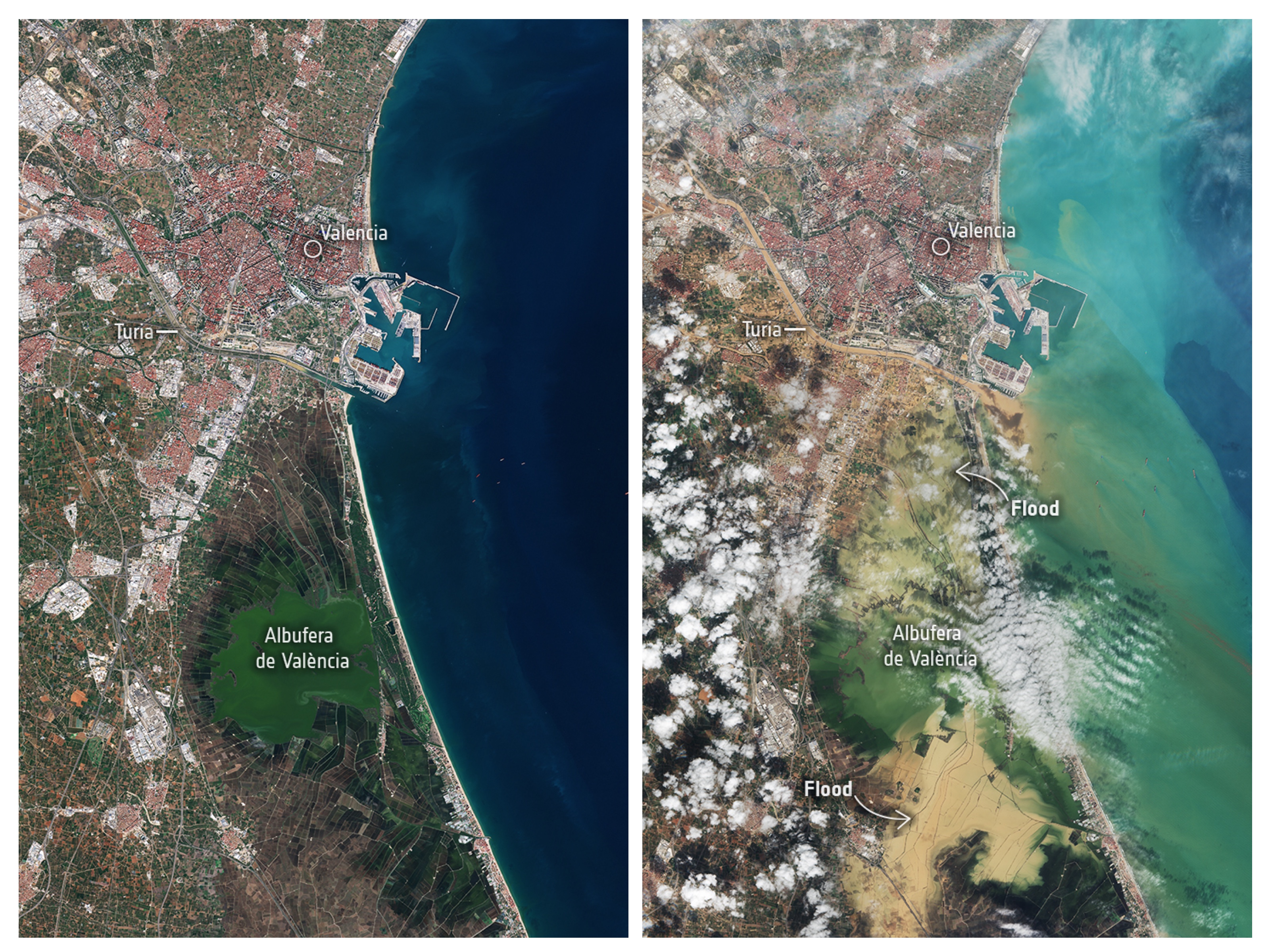
The images above (from 19 and 31 October) show the scale of the Valencia flooding disaster and the drastic transformation of the landscape. The Albufera National Park is severely flooded due to the discharge of the Magro, Turia and Poyo rivers. This park is bordered by the Mediterranean Sea to the east and encroaches on densely populated neighbourhoods to the west.
A few days later, the focus for the heavy rains migrated north with 150mm of rain falling in Barcelona, closing the airport, and suspending train services and schools. Over a month’s worth of rain (74mm) fell in one hour (Barcelona's average November monthly rainfall is 60mm).
Is climate change to blame?
The DANA is a recurring weather event that affects Spain roughly every 20 years, usually in the autumn months when there is a big temperature contrast between cool air from the north and the warm Mediterranean waters. A similar "cut-off" system in September 2023 (Storm Daniel) caused massive devastation in Greece and then moved on to Libya where it triggered the collapse of dams, causing massive loss of life.
But what made 2024’s DANA the deadliest weather event in Spanish history? The short anaswer is climate change and unusually high sea surface temperatures. A rapid analysis by World Weather Attribution found October 2024's heavy rainfall was about 12% heavier and twice as likely compared to a cooler pre-industrial climate.
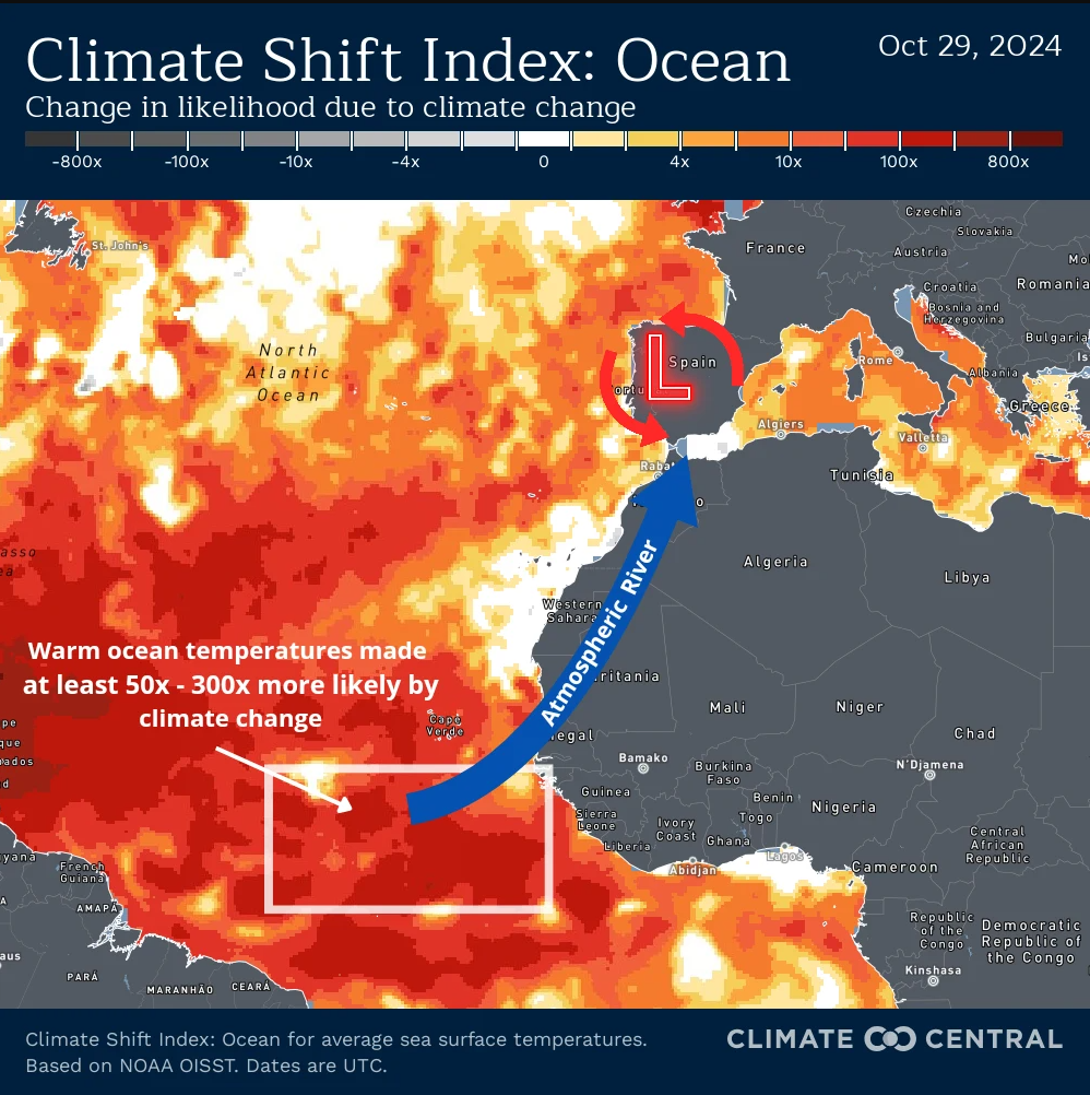
That's because a warmer atmosphere can hold more moisture, which leads to heavier downpours. The current 1.3°C increase in global temperaures since pre-industrial times means the air can carry about 9% more moisture. As for the unusually high sea surface temperatures of the Mediterranean that further fueled the storms, a separate analysis by Climate Central has shown that climate change made the warm waters 50 to 300 times more likely.

Other parts of Europe have also been badly hit by floods this year. In mid-September 2024, Storm Boris brought record-breaking rainfall and devastating floods to a large region of central and eastern Europe. The blocked area of low pressure in this case formed when cold polar air flowing from the Alps met very warm air across southern Europe. Almost 2 million people were directly affected by the floods, with a World Weather Attribution analysis calculating the rainfall was made twice as likely by human-induced climate change.
The world is on track for 3.1°C warming by the end of this century, which is expected to make rain heavier still, increasing the frequency and intensity of such events in future.


