
Storm names for 2023/24 announced
by Kirsty McCabe, FRMetS
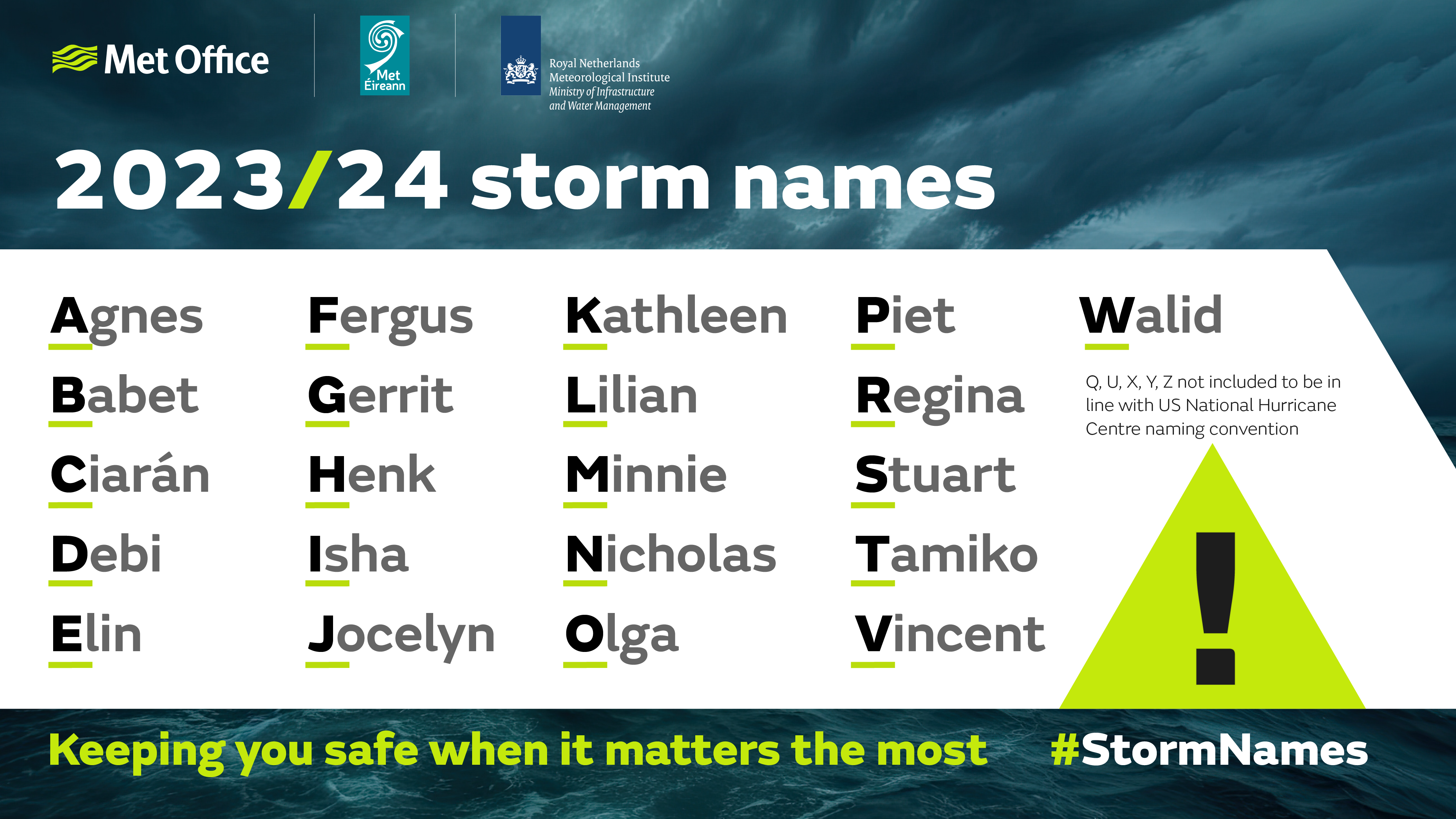
The storm names chosen for the 2023/24 season have been revealed – but will we get any further through the list than B this year, and why do we name storms in the first place?
Storms get named when they are deemed to have the potential to cause ‘medium’ or ‘high’ impacts, with wind the primary consideration. In addition to strong winds, impacts from rain and snow are also considered when it comes to naming storms. Naming storms helps to communicate the risks of severe weather – and it works.
In 2022, Storm Eunice was the strongest storm to impact England and Wales since February 2014, with a record gust speed of 122 mph. Met Office post-event surveys show that 99% of those within the red warning area for Storm Eunice were aware of the warning, and 91% of those took action to protect themselves, their property or business. The National Highways reported 21% less traffic on the roads in England on 18 February 2022 as people amended plans to stay safe.
First introduced by the Met Office, and Met Éireann (Ireland’s National Meteorological Service) in 2015, this is the ninth year of the Name our Storms campaign to help raise awareness of the potential impacts of severe weather by providing consistent, authoritative messaging. In 2019, the Royal Netherlands Meteorological Institute (KNMI), the Dutch national weather forecasting service, joined the collaboration.

The 2023/24 UK storm season runs from September 2023 through to the end of August 2024, with storms given a name when they are forecast to cause medium or high impacts in the UK, Ireland or the Netherlands. The first storm to be named this year will be Agnes, followed in alphabetical order by Babet then Ciarán. Just like the US National Hurricane Center naming conventions, there are no storms for Q, U, X, Y and Z. But for the first time, this year's list has broken with the traditional female/male ordering of names, to allow the inclusion of some of the more popular submitted names.
To avoid any confusion over naming, if a storm is the remnants of a tropical storm or hurricane that has moved across the Atlantic, the well-established method of referring to it as, for example, “ex-hurricane Kirsty” will continue. Similarly, if a storm is named by a different storm naming group (you can see the other groups in the image below) and impacts the British Isles, the given name will be used in communications, as occurred with Storms Otto (16 Feb) and Noa (12 April) in 2023.

So where do the names come from? Met Éireann’s submissions are inspired by famous scientists, including Jocelyn after the astrophysicist Dame Jocelyn Bell. Names from KNMI are often of Dutch origin and many were submitted by public visitors to the forecaster throughout the year.
This year the Met Office suggestions include names of people who work to protect the public in times of severe weather, as well as submissions from the public. Last year, we only got as far as the letter B, with two storms named in the 2022/23 season when Storms Antoni and Betty impacted the UK and Ireland in August.
So will Ciarán Fearon from the Department of Infrastructure in Northern Ireland, Debi Garft, who recently retired as Senior Policy Officer in the Scottish Government Flooding Team, Regina Simmons from Natural Resources Wales, or Stuart Sampson from the Environment Agency meet their monikers?
Let's hope not!
Meet Ciarán, Debi, Regina and Stuart
Ciarán Fearon
Senior Engineer, Rivers Directorate, Emergency Planning Unit,
Department for Infrastructure, Northern Ireland
Ciarán works closely with Met Office on a regular basis and especially during periods of severe weather ensuring relevant information is shared with colleagues in River’s operations, multi-agency response partners, and local community resilience groups. This information, which includes advice on river and lough levels, as well as any potential coastal impacts, allows for a coordinated preparation and response during these periods of severe weather.
He also liaises closely with the Flooding Incident Line, the public service for flood reporting, to ensure any flood calls are captured and dealt with appropriately allowing resources to be directed to those areas at risk.
Debi Garft
Recently retired Senior Policy Officer in Scottish Government Flooding Team
Debi was involved in the development of extreme weather response in Scotland, including the formation of both the Scottish Flood Forum and the Scottish Flood Forecasting Service. At the Scottish Government she had policy responsibility to support communities take action to understand and address flood risk, including making buildings and communities more flood resilient.
She was also responsible for improving the science and raising awareness of the impacts of coastal erosion and flooding on communities.
Regina Simmons
Team Leader, Warning and Informing at Natural Resources Wales
Regina's team at the NRW depends on the Met Office data and forecasts to predict and warn of river and coastal flooding across Wales. They take the forecast and run it through models, taking field data like rainfall amounts, river levels and tide information, bringing it all together to issue warnings through our free Flood Warning Service (FWS) in advance of flooding.
The Warning and Informing Team then make decisions about when to issue flood warning and flood alerts during times of severe weather and when there is heightened flood risk.
Stuart Sampson
Environment Agency’s Water Resources Security of Supply Manager
Stuart's role involves preparing and responding to severe weather, with a focus on droughts. He has been involved in managing droughts for 20 years at the Environment Agency. Outside of work he volunteers for work related to the other extreme, as a community resilience team leader to respond to flooding in his village.
Our improved understanding of the risks and forecasting of severe weather events, such as droughts, means that we can be better prepared and ready to respond.


