
Sea breeze circulation
When you visit the coast, you hope that it will be calm, dry and sunny, perfect sunbathing weather. The dry and sunny bit is often maintained throughout the day, but winds tend to increase through the late morning… as a sea breeze ‘comes in’. This is not a ‘normal’ breeze. It does not ‘follow the isobars’.
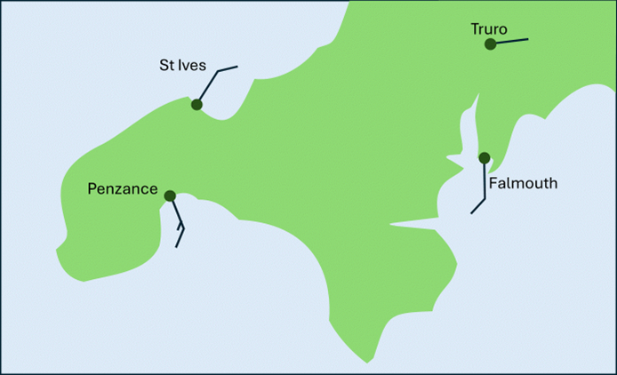
For example, in Cornwall, on the north coast, St Ives can have a significant northeasterly wind, while on the south coast, Penzance, has a significant southeasterly wind. They are only seven miles apart, so what’s going on?
It is all to do with temperature differences between the sea and the land, leading to something known as a ‘sea breeze’ circulation which happens on a local scale.
Now many years ago, when I was doing my ‘O’ level geography, I was told that the air over the land rises as it is warmer than the sea and this somehow ‘sucked’ air from the sea over the land, simple!
All was well until someone very clever/bored physicist worked out that the force generated in this way could not overcome friction at the surface. To quote the most used phrase in meteorology, “It’s more complicated than that!”
I will explain but to do so we need to take a short detour into the world of physics…
Heating the land
If the sun is shines on solid ground the surface heats up very quickly, however ‘solid’ ground is a very bad conductor of thermal energy. There is too much air between the particles. So, the heating is confined to a shallow layer of just a few centimetres. In fact, temperatures at 30cm below the surface barely change on a day-to-day basis. The sun heats only a small volume of ground. It can raise the temperature of the layer rapidly and by a large amount.
Heating the sea
On the other hand, water is ‘difficult’ to heat. Even in a laboratory, it takes around 5 times as much energy to raise water by 1°C as it does the similar volume of dry ground. Furthermore, energy can penetrate deeper into water, not very far but significantly deeper than over land. Like the land, water is a poor conductor, but it has another process, convection, to mix the energy to a greater depth. All this means that while sea surface temperature drift up and down seasonally they remain fairly stable on a day-to-day basis.
Air pressure, temperature and altitude
Surface air pressure at a point is a product of the weight of air over that point. Increase the mass of air and you increase the surface pressure and vice versa. It is common knowledge that air pressure decreases as altitude increases. What is less well known is that rate of decrease changes with temperature. The rate can be calculated using something called the ‘hydrostatic equation’. I will not go into details, but the hydrostatic equation tells us that the warmer the air the slower the rate that air pressure decreases as altitude increases.
Sea breeze formation
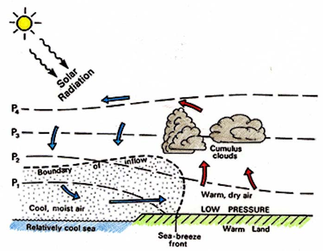
Now we need to use our imagination. Suppose we have two columns of air, one over the land and one over the sea. Each column has the same surface pressure and the same pressure at the top of the column. Let’s say the pressure is 1010 hPa at the bottom of the columns and 930 hPa at the top. That is the equivalent to around 3000 ft. At the start of the day, there is no horizontal pressure gradient at any height so no wind.
Now the air over the land heats up relative to that over the sea. The hydrostatic equation kicks in and, at our nominal height of 3000 feet above ground level (AGL), pressure becomes higher over the land than over the sea. There is no friction at 3000 feet AGL so air flows freely. Air is transferred from land to sea increasing the ‘amount’ of air over the sea. Fundamentally, surface pressure is a measure of mass of air over a point, so as mass increases pressure increases at ground level producing a pressure gradient from the sea to the land. But wait, there is now less air over the land, this causes surface pressure over the land to fall increasing the pressure gradient between the land and the sea at ground level. It is the combination of the two effects that produces enough force to overcome surface friction and complete the circulation. Once the process has started there is a feedback loop between the land and the sea, and the breeze tends to become stronger as the day wears on.
Sea breeze effects
The sea breeze circulation may develop in a similar fashion in most locations, but it is the interaction between the larger-scale weather situation, geography, tide and temperature which governs its effects. A slight outward wind at the start of the day aids the outflow above the ground and the sea breeze is stronger when it develops. Over a flat coastline like Lincolnshire and East Anglia, sea breezes can penetrate well inland. In the west, geography restricts its spread. Sea breezes on either side of a peninsula can converge to produce showers and thunderstorms. The classic example of this is over central Florida. Establishing effects at a particular location is tricky, my advice would be to talk to local fishermen. On this scale, years of experience may be a little more useful than a supercomputer.
Did you know?
- Wind speeds from sea breezes are usually about 4 to 8 m/s but can be even stronger.
- Air in sea breezes is cool and moist compared to the air over the land.
- Sea breezes can move 70km inland in temperate climates by 9pm in the evening.
- Sea breezes can be noticed several kilometres out to sea. In the tropics they can be felt 20km from land.
About the Author
Frank Barrow retired from the Met Office in 2020, after a career of 39 years during which he worked as an observer in the 1980s, a forecaster in the 90s and, since 1996, as a trainer at the Met Office College. He describes the latter role as “fitting him like a glove”, so he stayed... for almost 25 years! During that time, he was involved in the training of the vast majority of current Met Office forecasters.


 © Ed Hawkins, University of Reading")
