
Nowcasting: what happens next?
Nowcasting was first coined as a term by Keith Browning in 1981 to describe the process of understanding the current weather and forecasting out to a few hours ahead using weather observations. While complex simulations of the atmosphere are able to provide weather forecasts out to days and weeks ahead, it is possible to do an even better forecast for the next few hours on the basis of recent observations and an understanding of the current weather.
Take the example of the low pressure system over the UK on 18 October 2023. You can see the rainfall patterns over the south coast of England as observed by rainfall radar at 1200, 1300 and 1400 on 18 October below. The two bands of rainfall are present in each image, but have moved from south to north. This longevity in rainfall features can be used to predict where they will go next, using only recent rainfall radar data.
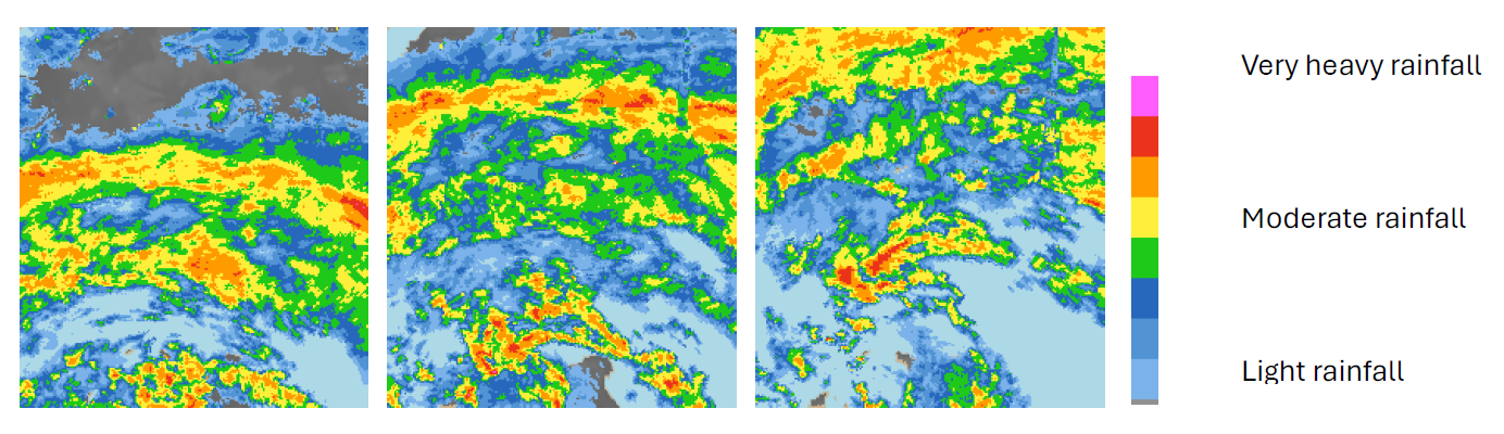
© Met Office
Humans do this intuitively when looking at a sequence of rainfall radar images and you can have a go yourself by looking at the recent rainfall radar observations on the Met Office website. Computers use a technique called Optical Flow to replicate this process of predicting the next image in a sequence and have been employed by national meteorological services for decades for nowcasting.
This way of predicting where and when it will rain can be helpful when our weather is driven by synoptic-scale features, such as weather fronts where we see the ascent of air and the formation of rainfall over large areas. Where rainfall is driven by smaller-scale ascent of air, such as those associated with thunderstorms, this becomes much more challenging as the rainfall features can change much more rapidly over the course of an hour or two.
The next set of images show rainfall patterns observed by rainfall radar over central Scotland on 6 May 2024. It’s much more challenging to guess how much rain will fall in this case because the rainfall patterns are changing so much from one hour to the next.
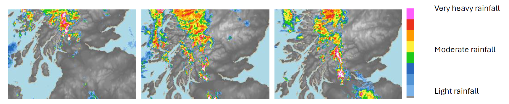
© Met Office
While rainfall radars are commonplace in wealthier countries, for large parts of the globe there is no radar network, and so alternatives are needed to help provide warning of severe weather. Satellite data is increasingly being used across the globe for nowcasting and to develop warning systems for severe weather. The rapidly cooling cloud tops associated with development of thunderstorms are readily observed from space. The launch of the Meteosat Third Generation of European weather satellites will give us further opportunities for nowcasting over Europe and Africa. The infra-red sounding instrument on these satellites will give us a better understanding of how favourable the atmosphere is for thunderstorm development. A lightning imager is also on-board and will provide us with more information on the location of lightning strikes.
While the severe weather from thunderstorms is a real motivator for nowcasting, more benign weather can also have an impact. At its peak, electricity generation from solar panels can provide around 10% of the energy needed by the national grid. The sudden formation or arrival of cloud can lead to dramatic changes in the power generation from solar and this variability is a challenge for those who manage our electricity supplies.
Nowcasting approaches are usually closely linked with those who are using them, be it in the energy sector, the general public or elsewhere. Summer 2024 sees the first trial of the Rapid Flood Guidance Service by the Flood Forecasting Centre which uses nowcasts to provide emergency responders with better information on flood risk out to 6 hours ahead, to help them in their planning and response to these events. With climate change leading to more frequent flash flooding driven by intense rainfall, improvements in nowcasting are more important than ever to provide early warning to those who will be affected.
About the author
Katie Norman leads the Nowcasting Research and Development Team at the Met Office. The team’s focus is on improving the forecasting of the hazards associated with thunderstorms out to a couple of hours ahead to inform the Met Office’s short range weather warnings and advice. Prior to this, Katie worked on improving the rainfall estimates from radar and the introduction of dual polarisation rainfall radar to the UK radar network.
 © Ed Hawkins, University of Reading")


